Northern Vietnam Mountains Loop in 10 Days: Ha Giang, Cao Bang, Sapa and Mu Cang Chai
How do you spend 10 days in the mountains of northern Vietnam?
Start in Hanoi, spend two nights around Dong Van on the Ha Giang loop, continue to Cao Bang and the Ban Gioc waterfall, take the night train to Sapa, then finish in Mu Cang Chai. Travel by car with a driver or as a passenger behind a local easy rider. Go in September or October for golden rice terraces.
This is a route for people who would rather spend ten days on switchback roads than on a beach. It leaves the coast, the big cities and the cruise boats to other itineraries and heads for the far north: the limestone plateau of Ha Giang, the border waterfall of Ban Gioc, the high valleys of Sapa and the terraced hillsides of Mu Cang Chai.
It is a demanding plan. Days are long, roads are narrow and the scenery is the reward. Two clarifications before you start. The Dong Van Karst Plateau is a UNESCO Global Geopark, not a World Heritage Site. And Sapa is not on the UNESCO list either, despite being one of the most photographed places in the country.
The route at a glance
| Day | Stage | Road time (approx.) | Night |
|---|---|---|---|
| 1 | Hanoi | none | Hanoi |
| 2 | Hanoi to Ha Giang | 6–7 hours | Ha Giang town |
| 3 | Quan Ba, Yen Minh, Dong Van | 5–6 hours | Dong Van |
| 4 | Lung Cu, Ma Pi Leng, Nho Que river | 4–5 hours | Dong Van |
| 5 | Meo Vac to Cao Bang | 6–8 hours | Cao Bang |
| 6 | Ban Gioc waterfall and Nguom Ngao cave | 4–5 hours | Cao Bang or near Ban Gioc |
| 7 | Cao Bang to Hanoi, night train to Lao Cai | 6–7 hours | Night train |
| 8 | Sapa | short transfers | Sapa |
| 9 | Sapa to Mu Cang Chai | 5–6 hours | Mu Cang Chai |
| 10 | Mu Cang Chai to Hanoi | 6–7 hours | Hanoi |
Times are indicative and depend on weather, road works and how often you stop. Mountain roads are slower than the kilometres suggest.
How to travel this loop
The plan works with a car and driver, or as a passenger behind a local easy rider on the Ha Giang and Cao Bang sections. It does not assume you ride a motorbike yourself. Many insurers exclude claims when the rider has no licence valid in Vietnam, and the roads are not a place to learn. If you are tempted, read renting a motorbike in Vietnam first and think about the safety question on the Ha Giang loop.
Ha Giang’s border province requires a permit for foreign visitors, which operators normally arrange. Confirm this when you book, carry your passport throughout, and expect checkpoints near the Chinese border.
When to go
September and October are the best months for this loop: the Mu Cang Chai terraces turn gold and the north has its best weather of the year. Late September to mid-October is the usual window, though the harvest moves from year to year. From roughly July to September typhoons and heavy rain can cause landslides and cancellations, so read about the rainy season and typhoons before fixing dates.
Winter is cold. From December to February Mu Cang Chai is very cold, often misty, and the terraces are bare. Sapa can come close to freezing. The loop is still possible, but the mountain views are less reliable and the riding is miserable.
Day 1: Hanoi
Land at Noi Bai, about 45–70 minutes from the centre by road, and keep the day light. Walk the streets of the Old Quarter, have a bowl of pho or bun cha and sleep early. The following day starts at dawn.
If you arrive with energy to spare, the Hanoi guide lists the lake and temple highlights close to the centre. Resist the temptation to fill the evening: you have nine more days of roads.
Day 2: Hanoi to Ha Giang
A minibus or private car takes the road north-west, roughly 300 km, in six to seven hours including a lunch stop. The road is mostly good for the first half and then climbs into karst country. Arrive in Ha Giang town in the late afternoon, check the weather forecast for the next two days with your driver or rider, and eat early.
This is where the plan separates from a coastal trip. The rule for the next days is simple: two major passes never back to back without a proper stop.
Day 3: Quan Ba, Yen Minh and Dong Van
Leave Ha Giang in the morning and climb to Quan Ba, where the twin mountains and the so-called Heaven’s Gate look over the valley. Continue through the pine forests near Yen Minh, with a long lunch to rest before the afternoon. The final stretch brings you to Dong Van, a small town of old stone houses in the heart of the plateau.
Stay two nights here. The plateau is a UNESCO Global Geopark, a status that recognises its geology and landscape; it is not a World Heritage Site, and you will not find that wording on any official list.
For those who prefer a pre-arranged package, the [Ha Giang to Ha Long mountains to sea journey](Ha Giang to Ha Long three-day journey) is one way to cover the loop with a guide, though it follows a different route from this itinerary. More options are in the Ha Giang loop tours guide.
Day 4: Lung Cu, Ma Pi Leng and the Nho Que river
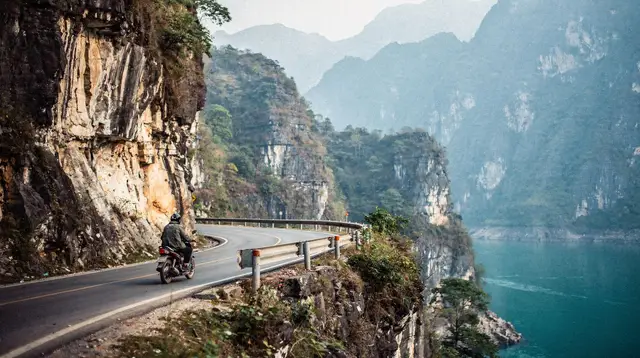
Today is an out-and-back from Dong Van, so you unpack only once. Drive to Lung Cu and its flag tower near the Chinese border, then return to cross the Ma Pi Leng Pass, the road cut into a cliff above a deep gorge. Stop at the viewpoints; the drop is dramatic and the light is best in the morning.
Descend to the Nho Que river for a short boat trip through the canyon if the water level and weather allow. Return to Dong Van for the second night. If it is a Sunday, the weekly market is worth a detour for the local textiles and food, though it is busy and tourist-oriented in places.
This is the rest day inside the loop: a pass in the morning, a boat and an unhurried evening.
Day 5: Meo Vac to Cao Bang
The longest road day of the first half. Leave early, passing Meo Vac and continuing east towards Cao Bang. The scenery softens from jagged karst to forested hills and river valleys, and the traffic nearly disappears. Allow six to eight hours with stops, and make sure your driver is comfortable with the road after dark in case of delays.
Arrive in Cao Bang town, a quiet place with a market, simple restaurants and few other visitors. Early bed again.
Day 6: Ban Gioc waterfall and Nguom Ngao
The drive to Ban Gioc takes a couple of hours through limestone hills and rice fields. The waterfall sits on the Quay Son river and marks the border with China, so you watch it from a viewing area and boat landing rather than standing at the base. Visit in the morning, when it is quietest, and photograph it again from the upstream bank if the light turns.
Nearby is Nguom Ngao cave, an easy, lit cave with large chambers and a gentle walk. Return to Cao Bang for the night, or stay in a homestay close to the waterfall if you want the early light.
A short motorbike excursion works here with a rider, and the [Cao Bang and Ban Gioc motorbike tour](three-day Cao Bang and Ban Gioc motorbike tour) covers this area as a passenger with a local rider. For more on the area, see the Cao Bang destination page and the Ban Gioc waterfall tours guide.
Day 7: Cao Bang to Hanoi, then the night train
Today connects two mountain regions, and it is mostly a transit day. Drive from Cao Bang to Hanoi, roughly six to seven hours, and eat dinner in the city. In the evening take the night train to Lao Cai, a sleeper service that saves a day of road and lets you wake at the foot of the Hoang Lien Son range.
Book the berth in advance, especially in September and October. If trains are full, a sleeper bus or limousine minibus also reaches Sapa overnight or early in the morning.
Day 8: Sapa
Arrive in Lao Cai at dawn and continue by road, about an hour, to Sapa. Drop your bags, have a strong coffee and spend the day in the Muong Hoa valley on a half-day walk between villages, with a local guide from one of the highland communities. Fansipan, at 3,147 m the highest peak in the country, can be climbed on foot over a long, demanding day or reached by cable car; clouds often hide the summit, so keep it flexible.
If you want a faster day, a [motorbike trip to the Dragon waterfall](motorbike tour to a waterfall near Sapa) gives you the surrounding valleys with a local rider. Remember: Sapa is not a UNESCO site. It is a mountain town in a spectacular landscape, and it has grown busy. If you are choosing between it and the Ha Giang loop for a shorter trip, the Sapa or Ha Giang comparison will help; this itinerary does both. See also the Sapa destination page.
Day 9: Sapa to Mu Cang Chai
Leave early. The road crosses the Tram Ton Pass, one of the highest in the country, then descends towards Than Uyen before climbing again to the Khau Pha Pass, the gateway to Mu Cang Chai. This is the one day where two major passes follow each other, so break the journey in Than Uyen with a long lunch and a rest, and stop at viewpoints rather than pushing through. Allow five to six hours and arrive before dark: the roads here are not for night driving.
Check in at a homestay and watch the light on the terraces from the first viewpoint you can reach. Evenings are quiet and often cool, even in autumn.
Day 10: Mu Cang Chai and back to Hanoi
Spend the morning in the terraces. Between La Pan Tan and Che Cu Nha the hills are carved into steps that glow gold in September and October, and early light brings the best photographs. A guided walk through the villages is the best way to see them; the [private full-day trek at Mu Cang Chai](full-day private trek through the terraces) is one option if you have the time.
Drive back to Hanoi in the afternoon, roughly six to seven hours, and arrive in the evening. Do not book an international flight the same night: a landslide or a slow convoy behind a truck can cost you hours. Give yourself the next morning as a buffer. For a deeper look at the region, read the Mu Cang Chai destination page and the rice terraces guide.
Practical notes
- Layers and rain gear: even in autumn the mountains are cool in the evening and showers are frequent.
- Cash: carry dong in small notes for homestays, markets and fuel stops. Cards are rare outside Hanoi and Sapa.
- Water: tap water is not drinkable anywhere in Vietnam, so buy bottled or filtered water.
- Connectivity: signal fades in the gorges. Download offline maps before leaving Hanoi.
- Emergencies: police 113, fire 114, ambulance 115.
- Place names: Vietnam merged its provinces on 1 July 2025, but the towns and sights in this itinerary kept their names.
If you only have a week for the north, the northern Vietnam in one week plan is gentler, and the Ha Long Bay and Ninh Binh in three days route covers the coast and limestone landscapes this loop leaves out.
Northern Vietnam mountains loop: questions answered
Do I need a motorbike licence for this itinerary?
No. The plan assumes a car with a driver, or riding pillion behind a local easy rider. Riding yourself without a licence valid in Vietnam is the usual reason insurers refuse a claim, so avoid it.
Is Sapa a UNESCO World Heritage Site?
No. Sapa is not inscribed. The Dong Van Karst Plateau near Ha Giang is a UNESCO Global Geopark, which is a different programme from World Heritage.
When are the rice terraces of Mu Cang Chai golden?
Usually around September and October, with the exact weeks changing each year. The terraces are green from about June, and the cold season from December to February brings bare fields and very low temperatures.
Is ten days enough, or too rushed?
It is enough to see the highlights but the days are long. Expect several drives of six to eight hours, so this suits travellers who accept road time as part of the trip.
Can I add Ha Long Bay or Ninh Binh?
Not without cutting something. This loop deliberately leaves the coast and the limestone plains of Ninh Binh to other northern itineraries.
How cold does it get in the mountains?
From December to February it is cold and damp in Ha Giang, Cao Bang, Sapa and Mu Cang Chai, and Sapa can approach freezing. Pack layers and a waterproof jacket in any season.
Motorbike Loops and Countryside Excursions
Verified deep-linked GetYourGuide tours. Book through these links and we earn a small commission at no cost to you.
GetYourGuide does not provide a product photo for this activity — the image shows the meeting point, photographed by us.