A loop that takes days, not an excursion
Ha Giang is the far-north mountain frontier of Vietnam, right up against the Chinese border, and its reputation rests on a single route: a looping ride of roughly 350 km through limestone peaks, deep gorges and highland villages. It is the best-known motorised adventure in the country, and it asks for time. Even the shortest sensible version takes three days, and four lets you breathe. This is not something you squeeze into a free afternoon from the capital; the town itself is about 300 km from Hanoi, six or seven hours on the road, which is why the real trip starts the day before the first viewpoint.
Two confusions are worth clearing up before you book anything.
The first is heritage status. The Dong Van Karst Plateau, the dramatic grey landscape at the heart of the loop, is a UNESCO Global Geopark. It is not a World Heritage Site. The two programmes differ, and Vietnam’s inscribed northern sites are places such as Ha Long Bay and the Imperial Citadel of Thang Long in Hanoi. The geopark label recognises geology and local culture, and it is quite enough of a reason to come.
The second is the question of who rides. Driving a motorbike yourself without the right licence is a genuine risk, not a technicality. If you crash without the proper permit, many insurers will refuse to cover the claim, and a medical evacuation from a remote mountain road can become very expensive. That is why so many visitors ride pillion with a local easy rider, someone who knows the road, the weather and the villages. The wider rules are covered in our guide to renting a motorbike in Vietnam.
What the loop actually is
The classic route leaves Ha Giang town and heads north through the Quan Ba pass, nicknamed the Heaven Gate, with its twin hills known as the Fairy Breasts. It continues through Yen Minh and its pine forests to Dong Van, then east along the Ma Pi Leng Pass to Meo Vac. From there it drops to the Nho Que River and returns to Ha Giang by Du Gia or by a more direct road through Bao Lac, depending on the operator and conditions.
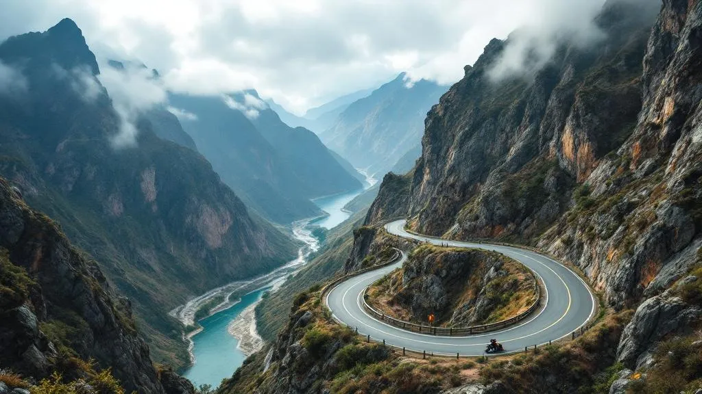
Roads are paved for the most part, but they are narrow, steep and switchbacked, with sheer drops, rockfalls in the wet season and logging or construction trucks sharing the bends. Daily distances look modest, around 100 km, but you ride slowly and the days are long. Expect six to eight hours in the saddle or on the pillion seat on the biggest stretches.
The Dong Van karst plateau
This is the geological heart of the trip. The plateau is a high, harsh limestone landscape where villages are built from the stone around them, fields are planted in pockets of soil between rocks, and walls of grey rock rise on all sides. The old quarter of Dong Van town, with its old-style houses and weekend market, is the usual overnight stop. Around it you can visit the Hmong King’s palace at Sa Phin, a mansion of the early 20th century, and the Lung Cu flag tower near the border, a climb of several hundred steps for views over the frontier.
Ma Pi Leng Pass
The pass is the signature moment of the loop: a road carved into a mountainside above the Nho Que River gorge, with the canyon dropping hundreds of metres below. Viewpoints and cafés sit along the road, and in clear weather the colours are extraordinary. In mist you may see almost nothing, which is why timing matters. The Tu San canyon beneath it can be crossed by boat on the river when the water level and the operator allow.
Villages and markets
Between the big viewpoints, the loop is as much about people as scenery. You pass Hmong, Tay, Dao and Lolo communities in highland villages, and markets in the area, such as the Sunday market in Meo Vac and Dong Van, bring them together. Be a courteous guest: ask before photographing individuals, and do not hand out sweets or money to children. Our overview of the ethnic minorities of northern Vietnam gives helpful context.
How long should you allow?
| Duration | What it covers | Verdict |
|---|---|---|
| 2 days | Rushed Quan Ba, Dong Van, Ma Pi Leng, return | Mostly riding; a taste only |
| 3 days / 2 nights | The classic loop with a stop at Dong Van and Meo Vac | The practical minimum |
| 4 days / 3 nights | The loop at a relaxed pace with side trips and the river | Recommended |
| 5 days or more | Loop plus Bao Lac, Cao Bang or the extended jeep route | For slow travellers and photographers |
Remember to add the road from Hanoi. If you are short on time, a three-day organised trip such as the three-day, two-night loop starting from Hanoi packages the transfer and the ride. If you prefer a slower pace, a four-day motorbike tour leaves room for the extra stops that make the ride worthwhile.
Getting there from Hanoi
There is no airport or railway at Ha Giang, so you arrive by road. Sleeper buses and limousine minibuses leave from Hanoi, many in the early morning or overnight, and take roughly six to seven hours to reach the town. Private cars with a driver are faster and more comfortable. If you are planning the logistics, our guide to sleeper buses in Vietnam explains the options, and getting around Vietnam covers the wider network.
If you travel independently, book the return in advance during peak months, particularly in autumn and around public holidays. Many organised tours include transfers both ways, which simplifies matters.
When to go: the seasons
Ha Giang has four distinct seasons, and the weather shapes the experience more than almost anywhere else in the country.
- Autumn (late September to November): the best season. Rice terraces turn golden around September and October, and pink and white buckwheat flowers cover the plateau in October and November. Skies are clearer and temperatures comfortable, although mornings and nights are cool at altitude. This is also the busiest period, so book ahead.
- Winter (December to February): cold and often foggy, with mist that can hide the great viewpoints for days. Temperatures at altitude drop close to freezing on some nights, and riding in the cold is tiring and sometimes unsafe. Dress seriously or choose another season. The Tet holiday, which falls between late January and mid-February on a different date each year, brings closures and heavy transport.
- Spring (March to April): mild, with drizzle and some mist. Peach and plum blossoms in the early part of the year, followed by greening hills.
- Summer (May to September): hot, humid and wet. The landscape is green and lush, but heavy rain can bring landslides and road closures, and the typhoon season in the north runs roughly from July to September. For wider context see our guide to Vietnam’s rainy season and typhoons.
If you can only choose one window, aim for the end of September through November. For terrace scenery in other parts of the north, compare with Mu Cang Chai and read our rice terraces guide.
What the loop demands of you
Be honest with yourself before you commit. The loop is a physical trip.
- Fatigue: long days on rough roads wear you out, even as a passenger. Aching back, sore legs and cold hands are normal complaints.
- Roads: hairpin bends, gravel patches, livestock and trucks. Guides know the road; independent riders do not.
- Weather: rain turns the surface slick and mist cuts visibility. Cold and wind are real at altitude.
- Health: carry basic medication and motion sickness remedies, and note that tap water is not drinkable anywhere in Vietnam.
- Insurance: check that your travel insurance covers motorbike travel and that your licence meets its conditions. See travel insurance in Vietnam.
Read our safety assessment of the Ha Giang loop for a frank view of the risks and how to reduce them. Violent crime is rare here; the road is the issue.
Easy rider, self-drive or car
| Option | Pros | Cons |
|---|---|---|
| Easy rider (pillion) | Local knowledge, no licence worries, can enjoy the view | Less independence, pillion fatigue |
| Self-drive with the right licence | Freedom, own pace | Real risk, insurance conditions, demanding roads |
| Car or jeep with driver | Comfort, weather protection, good for families and older visitors | Less immersive, fewer stops |
For most travellers who are not experienced mountain riders, the pillion or car option is the sensible one. A group tour such as the three-day motorbike tour is a straightforward way to see the loop, with accommodation, meals and a guide included.
Where to stay and what to eat
Accommodation is simple. Expect homestays with shared rooms, family-style meals and wooden stilt houses in the villages, plus small hotels in Ha Giang town, Dong Van and Meo Vac. In winter, ask about heating and blankets. Expect to eat dishes such as thang co, a horse or buffalo stew traditional to the Hmong, buckwheat cakes, grilled meats, corn wine and smoked pork. The vegetarian options are good but you should say so in advance. Cash matters in villages, so bring dong in small notes; our money in Vietnam guide has the basics.
Beyond the loop
If you have extra days, Ha Giang connects to other highlights in the north-east. Cao Bang lies to the east with the Ban Gioc waterfall on the Chinese border, and the detail of that circuit belongs to Cao Bang. A multi-day option such as the four-day Ha Giang to Cao Bang and Ban Gioc trip links the two. For gentler walking and valleys, go instead to Pu Luong or Sapa, and see Sapa or Ha Giang to decide between them.
Packing and preparation
Bring layers whatever the season, since altitude and mist can make a warm morning cold by afternoon. A windproof jacket, gloves, a buff, sturdy shoes and rain cover are essential. A full-face or good-quality helmet matters more than almost anything else on the list. Pack light, as space on the bike is limited, and keep a charged phone and a power bank. Our packing list for Vietnam can help you prepare, and the general Ha Giang loop tours guide compares operators and formats.
Border-area permits are normally arranged by the operator or accommodation, but requirements can change, so confirm at the time of booking. Most people base themselves in Hanoi before and after, so read our Hanoi destination guide for the capital, and the wider north Vietnam region page for planning other parts of the country.
Ha Giang loop: questions travellers ask
Can I do the Ha Giang loop in two days?
Technically a rushed two-day version exists, but you would spend most of it in the saddle on switchbacks and see little. Three days is the practical minimum and four is far more comfortable, with time to stop in villages and viewpoints.
Do I need a licence to ride a motorbike in Ha Giang?
Yes. Riding in Vietnam legally requires a licence valid for the machine’s engine size, and many insurers refuse to pay out after an accident if you did not hold it. This is why most visitors ride pillion with a local easy rider rather than driving themselves.
Is the Dong Van plateau a UNESCO World Heritage Site?
No. The Dong Van Karst Plateau is a UNESCO Global Geopark, which is a different programme from World Heritage. Vietnam’s inscribed sites in the north are places such as Ha Long Bay, Trang An and the Imperial Citadel of Thang Long in Hanoi.
When is the best time to visit Ha Giang?
Late September to November is the favourite window, with golden terraces and buckwheat blossoms. Winter, from December to February, is cold and often foggy with views lost in cloud. Summer is green but rainy, with landslides sometimes closing sections of road.
How do I get from Hanoi to Ha Giang?
Road is the way: sleeper buses and limousine minibuses leave Hanoi regularly and take roughly 6 to 7 hours to reach Ha Giang town. Most organised tours include the transfer from Hanoi, and many start with an overnight bus or an early departure.
How much does the Ha Giang loop cost?
In 2026 an organised easy rider loop typically works out at roughly 1,200,000 to 2,500,000 VND per day, around 480 to 1,000 NOK, depending on accommodation and what is included. Always confirm what the price covers, such as meals, permits and insurance.
Is the Ha Giang loop dangerous?
Violent crime is rare. The real risks are traffic, steep and sometimes wet roads, fatigue and weather. Choosing an experienced guide, riding at a sensible pace and avoiding night riding reduce the risk considerably.